Warm water, believed to be caused by human-induced global warming, is starting to take its toll on Antarctica’s great ice sheet as it’s starting to lose ground. According to a recent paper, warm water is circulating under the edge that is floating on the surface, warming it and causing it to melt.
Researchers at the UK Centre for Polar Observation and Modelling (CPOM) at the University of Leeds, conducted research looking into impacts of global warming on ice sheets on Antarctica. They created the first complete map that shows how the ice sheet’s submarine edge is starting to shift. Their findings were published in the journal Nature Geoscience on April 2.
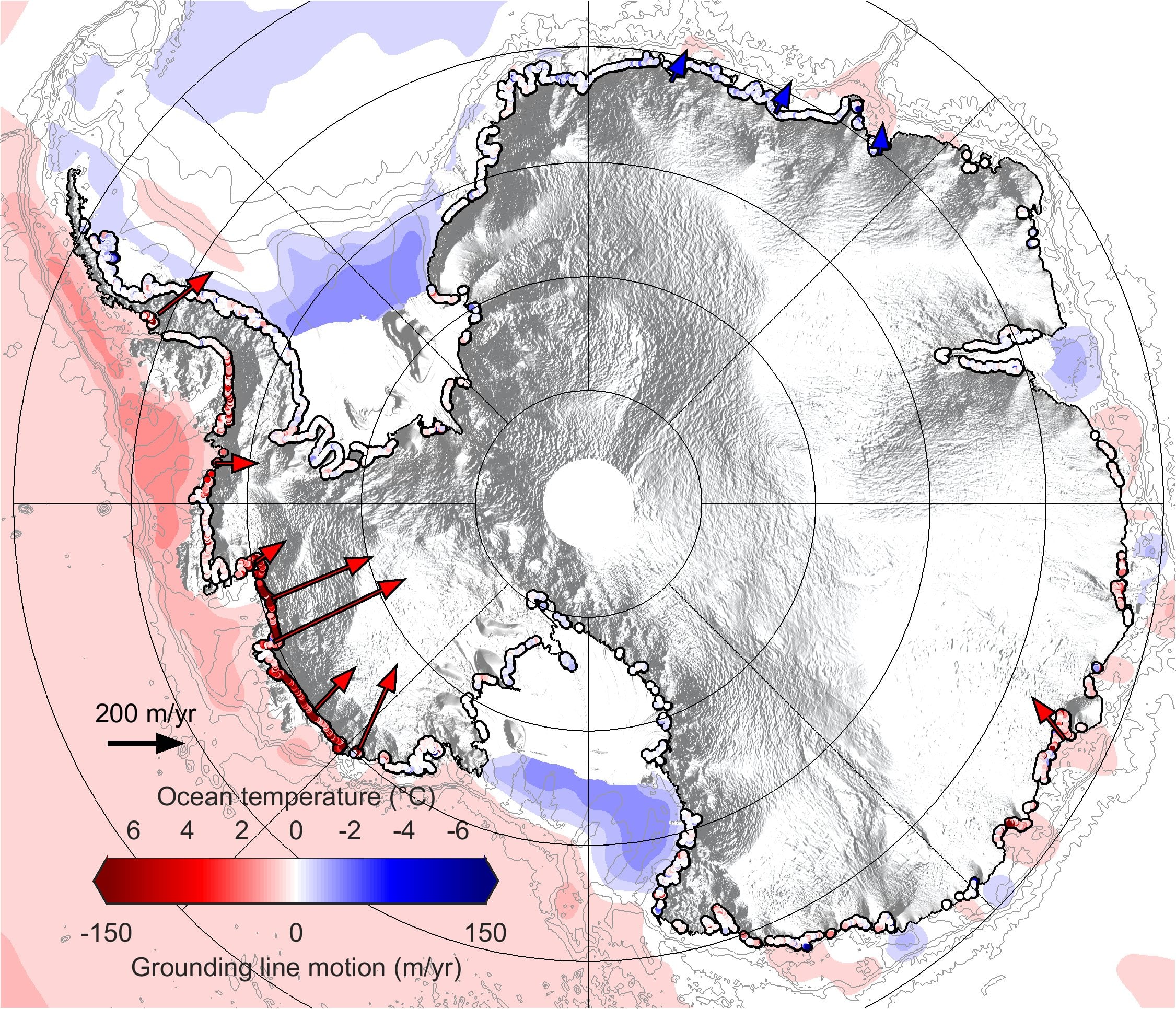
Dr Hannes Konrad from the University of Leeds and his team discovered that Antarctica’s great ice sheet is prone to its grounding line retreating, the place where the ice sheet’s base leaves the sea floor and starts to float. They discovered this alarming shift in eight of the ice sheet’s 65 large glaciers. Based on their observations, they found that 1,463 square kms of Antarctica’s underwater ice melted off Antarctica’s great ice sheet between 2010 and 2016. It’s worth pointing out that this area is the size of Greater London.
“Our study provides clear evidence that retreat is happening across the ice sheet due to ocean melting at its base, and not just at the few spots that have been mapped before now. This retreat has had a huge impact on inland glaciers, because releasing them from the sea bed removes friction, causing them to speed up and contribute to global sea level rise,” Dr Konrad said as per Phys.org. “These differences emphasise the complex nature of ice sheet instability across the continent, and being able to detect them helps us to pinpoint areas that deserve further investigation,” he added, pointing out the differences in other glaciers that aren’t as affected.
Those grounding lines are usually located a half a mile or more below sea level. That being said, it’s quite difficult to access them. The researchers relied on remote sensing methods that give them more accurate detection. Using this method, the team managed to detect the movement of Antarctica’s grounding line with the help of the European Space Agency’s CryoSat-2 across 16,000 km of the coastline. This helped so that scientists could successfully measure any change that would occur in the glacier and sea floor geometry, using Archimedes principle of buoyancy. This principle can help scientists as it refers to how thick the floating ice is as opposed to the height of the surface.
“We were delighted at how well CryoSat-2 is able to detect the motion of Antarctica’s grounding lines. They are impossible places to access from below, and usually invisible on the ground, so it’s a fantastic illustration of the value of satellite measurements for identifying and understanding environmental change,” Professor Andy Shepherd from the School of Earth and Enivornmental at Leeds and the co-author of the study, said in a statement on Phys.org.